Icelandic Saga Maps Data
Principle author: Emily Lethbridge
Additional contributors: Trausti Dagsson, Pétur Húni Björnsson, Logi Ragnarsson, Zachary Melton, Gísli Pálsson, Hjördís Erna Sigurðardóttir, Nikola Machackova
Contributing institution: University of Iceland
Publisher: University of Iceland
Date Created Begin: 2015
Date Created End: Ongoing
Spatial Coverage: Iceland, Norway, Denmark, Sweden, Greenland, Faroe Islands, United Kingdom, North America
Temporal Coverage: Early Viking Period - Modern, with focus on Early Viking Period, Late Viking Period, Early Medieval Period
Subject List (FISH Vocabularies): Events: Documentary research
Relation: None listed
Language: English; Icelandic
Format: jSON
Type: Collection, dataset, image, interactive resource, text
Creative Commons Licensing: CC BY-NC
Collection method(s): The text of each saga (in modern Icelandic) was uploaded into the ISM database. Place-names in the text were then identified and geo-referenced using search tools such as the lmi.is and ja.is websites to get GIS co-ordinates. In some cases, notes about difficulties re. locating places were made. Each named place in the saga text was given a place-type (i.e. farm, harbour, hill, etc). Once saved, all places mentioned in that saga subsequently appear on the map interface. Clicking the place-name on the map brings up the chapters in the saga it appears in. Users can also retrieve a list of other sagas/chapters that reference that place. The relevant saga text can be read on the right-hand-side of the map. Place-names in the text are hyperlinked to the map and clicking on them in the text makes them appear on the map.
For concept data, texts of the sagas were read through and concepts (selected in advance, not all of them) were identified in individual chapters. Individual chapters were then tagged with relevant concepts. By default, the concepts will be geographically located since (with few exceptions) all chapters contain geo-referenced place-names.
For manuscript data, a list of manuscripts containing saga texts was compiled with information about each manuscript's classmark, individuals (scribes, owners, collectors), and geographical locations associated with each manuscript.
Objects/samples collected: Icelandic place-names; English translations of Icelandic place-names; Narrative text that illustrates concepts core to the dataARC project/ontology; Manuscripts that preserve saga-texts produced in Iceland from the medieval period to the 19th century.
Why are you collecting this data/overall objective?: The overall objective of the Icelandic Saga Map project is to illustrate the relationship between geographical places mentioned in the sagas and the saga narratives themselves (as well as concepts with an environmental dimension that occur in the sagas). Icelandic Saga Map is a tool that enables spatial reading of the sagas, as well as a framework to explore the transmission of the sagas in a landscape context.
How will you use this data?: I use the data in my own research on the sagas and saga landscapes. Other researchers use it (and the data) as an exploration tool. It is also used in teaching and in cultural tourism.
Important points of interest within data: Some places named in the saga texts are difficult or impossible to identify in modern-day Icelandic landscapes. It is important too to remember that the sagas are not historical documents in the sense that they record events contemporaneously: they are literary creations with a strong oral basis, and as such, the relationship between places in the narratives and 'real' places can be complicated and is not necessarily a direct 1:1 relationship.
Not all concepts on the dataARC concept list were mapped onto the texts. Selection was necessary in order to make the concept mapping exercise achievable. Concepts selected were chosen in an effort to overlap as much as possible with other datasets, thus they are mostly related to the environment rather than other more thematic topics (i.e. political/social themes, etc).
Mapping the manuscript data onto the saga-places data will provide interesting insights into the extent to which Icelanders focused on local narratives, i.e. copied or owned sagas that took place nearby, rather than in other parts of the country. It will also give us a sense of how far individual manuscripts traveled around Iceland (and beyond) when they changed hands over time.
Publications: None at this time (Jan 2021)
Description: The Icelandic Saga Map database contains geo-referenced texts in Icelandic and English, with specific emphasis on medieval Icelandic sagas. All geographical places mentioned in the texts are displayed on a map interface with the text alongside. Other data pertains to medieval and post-medieval parchment and paper manuscripts of the geo-referenced saga texts, and to Icelandic travel books.
The text of each saga (in modern Icelandic) was uploaded into the ISM database. Place-names in the text were then identified and geo-referenced using search tools such as the lmi.is and ja.is websites to get GIS co-ordinates. In some cases, notes about difficulties re. locating places were made. Each named place in the saga text was given a place-type (i.e. farm, harbour, hill, etc). Once saved, all places mentioned in that saga subsequently appear on the map interface. Clicking the place-name on the map brings up the chapters in the saga it appears in. Users can also retrieve a list of other sagas/chapters that reference that place. The relevant saga text can be read on the right-hand-side of the map. Place-names in the text are hyperlinked to the map and clicking on them in the text makes them appear on the map.
Retrieve full project and record-level metadata for Icelandic Saga Maps Data on Github.

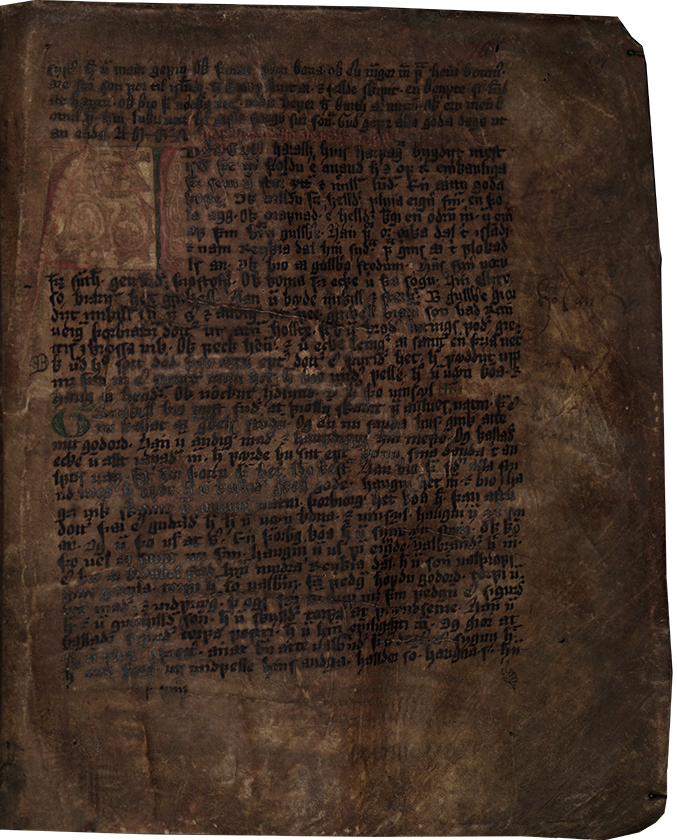
Late 15th-century saga manuscript containing three sagas about outlaws. The manuscript is associated with the West Fjords and the page shown above is the beginning of Harðar saga og Hólmverja.
Image copyright: Árni Magnússon Institute for Icelandic Studies
Data provided by
University of Iceland
